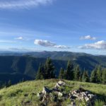
The St. Joe Mountains run east-west, sandwiched between the South Fork of the Coeur d’Alene River to the north and the St. Joe River to the south. To the west they are bordered by Lake Coeur d’Alene and the Palouse, and the eastern demarcation is the Bitterroot Mountains. The St. Joe Mountains are part of the Bitterroot Range.
| Photo | Trail | Rating | Difficulty | Distance | Duration | Elevation Gain | High Point | Low Point | Type | Features | Status | Administration | Fees and Permits | Maps | Open To | Season | Trail# | Resources |
|---|---|---|---|---|---|---|---|---|---|---|---|---|---|---|---|---|---|---|
 | Lemonade Peak Loop | 3.4 / 5 | More Difficult | 27.2 mi | 10:59 h | 6,884 ft | 5,659 ft | 2,428 ft | May – October | 8, 44, 252, 555, 563 | ||||||||
 | Mastodon Mountain Loop | 3.1 / 5 | Moderate | 18.2 mi | 7:37 h | 4,181 ft | 5,958 ft | 3,175 ft | May – October | 160, 10, 8, 226, 165, 158 | ||||||||
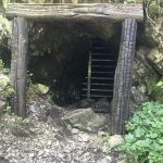 | Pulaski Tunnel | 2.4 / 5 | Moderate | 3.9 mi | 1:17 h | 713 ft | 3,671 ft | 2,895 ft | Year-around |
© 2016 – 2026 NaughtyHiker. All rights reserved. No duplication without permission.